


Rental GeoSLAM ZEB Horizon
SKU: K_GS_HORIZON_RENTAL
Rent with 
No capital outlay & no depreciating asset
Service & maintenance outsourced
Try before you buy
Eliminate down time
Mitigate risk of drone advancements
heliguy™ Rental Guide
In order to rent a drone with heliguy™ you'll need to have to hand:
CAA Flyer ID - The ID that identifies you as a pilot. Available for free from the CAA. You'll need to pass a simple multiple-choice test to get a Flyer ID.
Proof of Training - If you're renting a drone that weighs 250g or more (Mavic Mini 2 is exempt), you'll need to prove you're a qualified pilot by providing us with proof of an A2 CofC, GVC or PfCO qualification.
Proof of Insurance - We recommend getting instant, cost-effective cover for your rental with Coverdrone. Simply choose heliguy™ has the hirer name and use info@heliguy.com has the hirer contact email so that we're notified of your insurance policy
Once you've got these documents to hand - simply choose the dates for your booking and upload the required documentation.
Rental GeoSLAM ZEB Horizon
Full Description
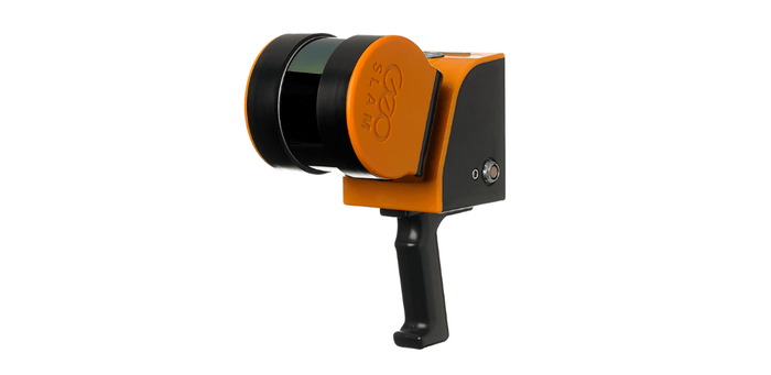
geoslam zeb horizon
Drone mounted aerial LiDAR solution.
LiDAR Point Clouds In Minutes
The GeoSLAM ZEB Horizon is a LiDAR solution which can be integrated with a drone.
This 3D scanner and laser-mapping product has a range of 100m, making it great for outdoor uses, especially where features are further apart.
Lightweight and compact, the ZEB Horizon can capture 300,000 points per second with an accuracy of 1-3cm. This fast data capture is complemented by easy processing.
It can be used in remote areas with poor GPS and enables operators to capture data for 3D modelling, conduct material volume and tonnage calculations, and collect floorplan and building measurements.
The ZEB Horizon is compatible with DJI drones, such as the M300 RTK and M600 Pro, integrated via GeoSLAM's UAV mount (to be purchased separately).
The ZEB Horizon is ideal for a range of applications, such as forestry, industrial and housing estates, power lines, railways, farming, mining, and construction sites.
Data collected from the ZEB Horizon can be processed via GeoSLAM Hub & Draw.

Key Features Of ZEB Horizon
Key features of ZEB Horizon include:
- Simple and easy deployment
- No additional positioning sensors required
- No need for GPS
- See intensity values
- Flight plan according to the area, features and overlap
- Processing on site – data quality and coverage check
- Merging multiple dataset – automatic in GeoSLAM HUB
- Georeferencing possibility – checkerboard, spheres, white lines etc.
- Camera availability – point cloud coloring, mesh creation
Why Use Drone LiDAR?
LiDAR is a remote sensing technology that uses rapid laser pulses to map out the surface of the earth.
LiDAR is useful when used to create high-resolution digital surfaces, terrain and elevation models used for various applications.
When it comes to surveying land with dense vegetation, where the light pulses can still penetrate between branches and leaves, LiDAR is particularly useful and can collect highly-detailed information.
Drone LiDAR systems, such as the GeoSLAM ZEB Horizon, allow companies and organisations to collect quick and accurate aerial data - more efficiently and safely.
A LiDAR-equipped drone can be deployed easily, making a single pass over the site, and the collected data can be processed rapidly.
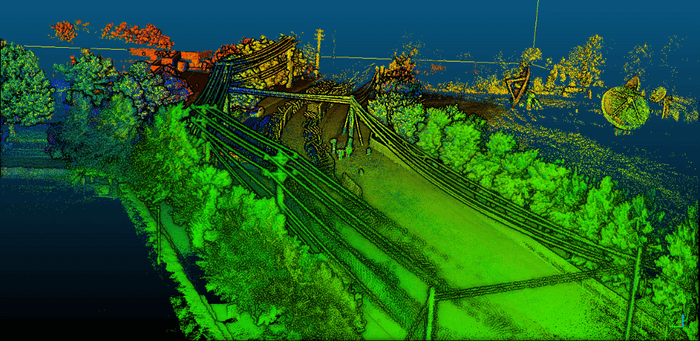
The LiDAR point cloud (pictured) was captured and processed using GeoSLAM technology.

GeoSLAM Hub And Draw
The ZEB Horizon can be combined with GeoSLAM Hub and Draw - a comprehensive software suite that provides an end-to-end scan-to-plan workflow, transforming your data into actionable information and valuable deliverables.
GeoSLAM Hub combines industry-leading SLAM (Simultaneous Localisation And Mapping) technology with powerful post-processing functionality.
This software package helps to generate accurate 3D point clouds from your data, has drag and drop functionality for simplified workflows, and produces survey-grade accuracy.
GeoSLAM Hub comes with each GeoSLAM system purchase and Draw can be bought separately, with a number of different licences available.
Product Specification
Range: 100m
FOV: 360 x 270
Protection Class: IP54
Processing: Post
Scanner Weight: 3.7kg
Coloured Point Cloud: Yes (with ZEB Cam)
Intensity: Yes
Scanner points per second: 300,000
Number of Sensors: 16
Relative Accuracy: 1-3cm (environment dependent)
Raw Data File Sizxe: 100-200MB/min
Accessories: UAV Mount for flexible airborne integration
What's in the Box
ZEB Horizon Surveying system
ZEB Horizon scanner
ZEB Horizon data logger with shoulder strap (incl. 14.8V battery)
14.8V Battery charger
ZEB Horizon main cable 1.5m length
USB memory stick
Reference base
GeoSLAM Hub software


